
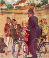
On the Trail of Peterswood
Article by Keith Robinson (updated June 17, 2009)
The village of Peterswood is a typical Enid Blyton setting, a friendly little place with narrow country lanes, old houses, a bakery on every corner, and a picturesque river. Everything's postcard-pefect. So where is it exactly? When I read all these books with my Enid Blyton reading buddy, Geoff, we were keen to Find Out.
We didn't have the resources of the internet back then, so we drew on details from the books. We knew there was a river running through Peterswood, and we knew from references to nearby Marlow and Maidenhead roughly where to look. So we decided Peterswood was based on a little village called Cookham, right next to the Thames somewhere between the aforementioned real-life towns. We got on a bus and rode up there, determined to find the place where Fatty and the others sat by the river, and to get some inkling of the sort of place they lived in.
Naturally we didn't find anything. Cookham is a very nice place, but when it really comes down it there are scant details in the books to give any clue as to where the kids might have lived. We went home a little disappointed.
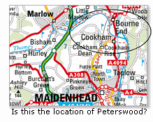
About twenty years later I read on the internet that Enid Blyton lived first in a place called Beckenham and then, in 1929, moved to Old Thatch Cottage close to the River Thames at Bourne End, Buckinghamshire. Then she moved to Green Hedges in Beaconsfield. I don't know for sure but I now think Peterswood is based on Bourne End (which is very close to Cookham).
In The Mystery of the Pantomime Cat, the newspaper confirms that Peterswood is in Bucks (Buckinghamshire). There's mention of "Bourne Wood" in The Mystery of the Hidden House. Whether this is an actual place or not, the name can't entirely be coincidence...can it? In the same book, Fatty mentions that Peterswood is about three miles from Marlow. Bourne End is also about three miles from Marlow. And in The Mystery of the Vanished Prince there's a place called Maidenbridge, possibly a play on the name of real-life Maidenhead (although in the book Maidenbridge is only two miles away from Peterswood).
So is Bourne End the fictitious Peterswood? See below for an update to this page, where a couple of Find-Outers have supplied a lot more information. But first...
Villages and towns mentioned in the books
According to the books, there are many small towns and villages located around the Peterswood area. Some are within biking distance, others are a bus ride away... but virtually all are fictitious.
Wilmer Green is about five miles away. Horace Peeks lives there in The Mystery of the Burnt Cottage.
Farring is fairly near Peterswood. The children set off to find Luke, suspecting he might be staying with his friend Jake at the circus in The Mystery of the Disappearing Cat.
Little Minton is where Miss Crump lives in The Mystery of the Secret Room. She was the previous owner of the deserted Milton House, where the secret room is.
Sheepsale is a friendly market town. In The Mystery of the Spiteful Letters, said letters were postmarked from this place and the Five Find-Outers get on the bus to visit, incidentally passing another village on the way called Buckle. Also in this book, Gladys (the Hilton's housemaid) goes to stay with her aunt at Haycock Heath after receiving a spiteful letter, and right at the end of the book Inspector Jenks suggest tea for all at a big hotel in Nutting.
Sheepridge is, apparently, a short walk away across the fields. In The Mystery of the Missing Necklace the Find-Outers set out to buy some old trousers there, for one of Fatty's disguises, but instead find some on an old scarecrow on the way. This town also turns up in The Mystery of the Pantomime Cat, although in this book the Find-Outers take the bus to get there. It's where one of the suspects, Alec Grant, performed his play. In The Mystery of the Invisible Thief, Fatty jumps on the bus to visit a second-hand clothing shop, where he buys a huge pair of boots. Would this be the place he intended buying old trousers from in Missing Necklace?
Marlow is first mentioned in The Mystery of the Hidden House and is the first actual real town to be featured in a Five Find-Outer book (unless you count London, which was mentioned in a previous book). Marlow is on the map above, and is "within three miles" of Peterswood according to Fatty, who rides there on his bike to visit Mr Holland's garage. Marlow is also mentioned very briefly in subsequent books.
Maidenbridge is two miles away, and in The Mystery of the Vanished Prince the Find-Outers head down there to see a woman about her twin babies. But they have the wrong address, so end up heading instead to Tiplington (a bike ride away) where a baby show is being held. Later they find out the Prince is being held at Raylingham Marshes—a desolate place with just a couple of houses. Mr Goon takes the train to Raylingham Station, but the Find-Outers take the bus.
Maidenhead pops up in The Mystery of Tally-Ho Cottage. A-ha! The second actual real place! This is where the Lorenzos, on the run from the police, were spotted. Later that night they take a motor boat along the river to Tally-Ho Cottage. Taplow, the third real place, is mentioned along with Maidenhead and Marlow in The Mystery of the Strange Messages, as possible towns where a house called The Ivies might be located.
Real-life locations
The following emails were received within a day of each other from clever Find-Outers. First, Pankaj Saxena from Chicago, IL, USA, wrote the following on June 15, 2009:
I grew up in India, reading Enid Blyton books, and the Five Find Outers series were probably my favorites.
One of the "fictional" places you've named was Sheepridge, which Enid Blyton mentions in 3 separate books. Sheepridge actually refers to a real place, which would have been familiar to Enid Blyton, though name changes and the expansion of neighboring villages seems to have swallowed it up.
Here's some supporting evidence I could find on the web after a quick search.
- Enid Blyton's home (Old Thatch) in Bourne End is on Coldmoorholme Lane, which runs in a north-south direction between Marlow Road (A4155) and the River Thames. If you go north on Coldmoorholme Lane past Marlow Road, it runs into Sheepridge Lane. Sheepridge Lane runs north and east and connects Bourne End to the village of Flackwell Heath. The distance is about 3 miles by road, though probably closer to 1 mile as the crow flies.
- Sheepridge Lane even today runs through mostly farmland, which fits with the description of the Five Find Outers finding the scarecrow on a farm.
- This website has about 20 photos of Sheepridge and nearby areas. The photo captions suggest that Sheepridge is the area north of Bourne End and west of Flackwell Heath, which fits in with the description above. As you can see in the photos, there are a lot of farms. More precisely, it's the little hamlet on Sheepridge Lane where the road takes a dogleg to the east. This is also the area found by searching for Sheepridge on Google Maps.
- Historically, the area north of Bourne End was heavily wooded. A map of the area published by Andrew Bryant in 1825 shows several woods north of Old Thatch (Enid Blyton's home in Bourne End). You can see a copy of the map here. According to the map, the woods included Oakridge Wood, Broom Wood, Sheepridge Wood and Martin's Wood. Oakridge Wood and Broom wood are still there, according to Google Earth. Sheepridge Wood has been partially cleared to create farms, and the hamlet of Sheepridge. Martin's Wood is almost completely gone (replaced by farms and the northern part of Flackwell Heath), except for a little strip just to the west of Flackwell Heath.
- Many of the major roads shown in the 1825 map still exist. Marlow Road, Coldmoorholme Lane (on which Enid Blyton lived), and its northern extension Sheepridge Lane are all there, pretty much following the same path they did in 1825. If you compare the map from 1825 and a modern road map, you'll see Sheepridge is located exactly at the dogleg on Sheepridge Lane, which the old map shows as the location of Sheepridge Wood.
So it seems to me that the little hamlet at the dogleg of Sheepridge Lane was probably known as Sheepridge in the 1930's, when Enid Blyton lived there. Today, it's been absorbed into Little Marlow - Flackwell Heath.
This page lists a business at the exact location of Sheepridge. It's a pub, called "The Crooked Billet". It may well have been around in the 1930's, and the owners might know what "Sheepridge" referred to in those days. The phone number is listed on the web page.
I enjoyed reading your article. It brought back a lot of fond memories.
Then, Graham Wheeler in High Wycombe sent the following on June 17, 2009:
Indeed the lane that Enid Blyton lived in, Coldmoorholme Lane, is obviously the location where the children live and it fits many of the stories perfectly. The lane is a dead-end, leading to the river, with a single-track branch railway line and pedestrian level crossing (known as Spade Oak crossing to railwaymen) at the bottom, which must be crossed to reach the river. The railway line is the Marlow Donkey that shuttles between Bourne End and Marlow. The river is mentioned in several stories and the railway line is mentioned in at least one story too.
Next door to Enid Blyton's cottage is the Spade Oak Hotel, but in Blyton's day it was called "Ye Ferry Hotel". This is certainly the prototype for the hotel where Fatty stayed in the first book. The hotel was obviously named after a ferry service which existed until 1956. The ferry is mentioned in the Pantomime Cat. The landing stage (or wharf as it was known) is also mentioned in one book (Some supposedly stolen goods were thrown into the river there). It seems that the ferry transported people to Cookham on the other side of the river. There are only fields directly opposite, so I guess that the ferry's main work was carrying day-trippers across to the quieter side of the river, as the kids did in Pantomime Cat. Railway excursions to riverside locations were very popular in the first half of the twentieth century. Marlow, Henley, Bourne End, Cookham, Twyford, Windsor, Maidenhead were all popular excursion destinations. People came from as far afield as Manchester and Nottingham to visit Marlow in particular (which I have seen the adverts for). Marlow received several excursion trains a day during the summer, and the original Marlow station had an unusually long platform (for a branch terminus of its type) to accommodate these excursion trains. The length of the platform and the existence of a couple of fairly long "mystery" sidings puzzled me for years until I connected them with the excursions. The sidings, of course, would hold the excursion trains until the return journey. It was usual for the excursions trains to drop off the passengers at one station, say Marlow, and pick them up at another station, say Windsor, and the passengers had a river-boat trip between the two locations as part of the excursion package. It provided the opportunity for the locos to be turned around somewhere too.
There are photos of a Marlow / Maidenhead "Riverside Special" at this link, although this is 1956 and is well after the riverside excursion's heyday.
Bourne End would have had its fair share of excursionists too. Its station also had a long platform for excursion trains. Indeed, summer day-trippers being a hindrance is mentioned in one of the Blyton books. Bourne End being a popular riverside destination, it would have had a fair sprinkling of tea-shops, ice-cream parlours and the like, so the frequent mention of them in the books would be (sort of) authentic. Another feature of the Coldmoorholme Lane area is that there are a number of streams and water-courses nearby and, at one time, a number of mills too, so Ern following a stream as in "Hidden House" could also be regarded as authentic. Although the absurdity of a stream and mill being high-up on a hill does not exist in the real world.
Bourne End did (until very recently) have a police house rather than a police station, just like in the books. The police house is about to be replaced with a Tesco's mini-market, and there is no police presence in Bourne End whatsoever now. One of Blyton's inconsistencies is that the police house magically transforms itself into a full-blown police station in one book, with steps leading up to it and lots of policemen coming and going, only to transform itself back into a police house in a later book.
Peterswood seems to have eventually become a hybrid of Bourne End and Beaconsfield, notwithstanding Enid Blyton's usual inconsistencies. For example, in the "Hidden House" the children walk up "the station slope", but Bourne End Station does not have a slope. Beaconsfield Station, on the other hand, is in a cutting and the vehicular approach-ways to the platforms entrances are quite steep slopes, one for each platform on either side of the tracks. In one story a road called Jordans Road is mentioned, but Jordans is a real place near Beaconsfield; nowhere near Bourne End.
Sheepridge is a real place, although it is just a hamlet consisting of a pub and a few houses. There is no way that Fatty could have purchased anything other than a pint of beer there, even in Blyton's day. Blyton probably derived the name from Sheepridge Lane, which is almost directly opposite the entrance to Coldmoorholme Lane. Sheepridge Lane is a hill, leading to Flackwell Heath. Sheepridge is half-way up the hill. Logically, Sheepridge should be Flackwell Heath, and in the Blyton books it probably is. She may have been unaware that Sheepridge is a hamlet half-way up the lane, because it is not physically marked or sign-posted as such except on Ordnance Survey maps. Flackwell Heath is a fairly substantial village complete with shops, and a golf course that Enid Blyton undoubtedly used, because it was just about the only one in the area in her day - and she was golf mad.
See photos of Sheepridge here and here.
In this map, Sheepridge is shown in the top centre square. Coldmoorholme Lane is in the bottom centre square. The P.H. indicated on the map in that square being the hotel next to Blyton's cottage. I have been told that Enid Blyton is buried (in secret) in Little Marlow cemetery, although I have not bothered to check this out. This is a hidden-away cemetery without a church, indicated by "Fern" in the centre-centre square of the map. It makes sense that she should be buried there, because her grieving fans would be looking in Beaconsfield, but instead she would be hiding in a cemetery miles away that no one would know about unless they were very local. If she is buried there, she is in good company - Edgar Wallace is buried there too.
Some places in the books seem to match Cookham rather than Bourne End. Christmas Hill in "Hidden House" is probably Winter Hill in Cookham. Although it is on the other side of the river, it could almost certainly be seen from the end of the lane she lived in, if not from her cottage itself. "The nearest big town" where Inspector Jenks works would logically be High Wycombe in the days of Buckinghamshire Constabulary. Sheepsale, being a market town, would logically be High Wycombe too.
It would be wrong to attempt to relate fictional places to real places in all Blyton's stuff, it is just that Bourne End matches so much that it is obviously the setting. A real place, albeit renamed, has probably been used as an aid-memoir, but it has been distorted, contorted, and merged with other places to suit the various stories. She is notoriously inconsistent in most of her series-type books, particularly in her later years. She has far more villages around Peterswood than really exist, so most are obviously fictional, although Peterswood and Bourne End gradually becomes merged with Beaconsfield - there are several occurrences where Becaonsfield is a more likely setting.
Thanks to both and Graham for the detailed information and links. The Find-Outers have well and truly been found!